
Pokémon GO users concerned as AR data is utilized for robot delivery
포켓몬 고 유저 AR 데이터 ‘로봇 배달’ 활용 소식에 들썩
2026.03.17 17:17 UTC+9
AI Summary
Niantic is using Pokémon GO’s crowdsourced AR data to train AI for delivery robots. Players are raising privacy concerns over the commercial use of their location data. The technology aims to solve urban navigation hurdles that traditional GPS systems struggle to manage.

It has been revealed that various metadata, including AR data from Niantic’s flagship title, Pokémon GO, is being used to enhance the precision of delivery robots.
This news was reported by the U.S. technology media outlet MIT Technology Review. The report details how Niantic is refining its AI technology based on data accumulated through its games, thereby building more accurate location information. In particular, it was noted that the vast amount of images and location data collected during the gameplay of Niantic’s core AR titles are being utilized for AI training.
At the core of this learning process are the images captured by game users and their associated metadata. As players scan PokéStops, gyms, and various landmarks in Pokémon GO to earn rewards, the GPS coordinates, camera angles, timestamps, weather conditions, and movement patterns collected via AR features are recorded on the server. Based on this massive amount of crowd-sourced data, the system can identify the status of specific areas or locations with centimeter-level precision.
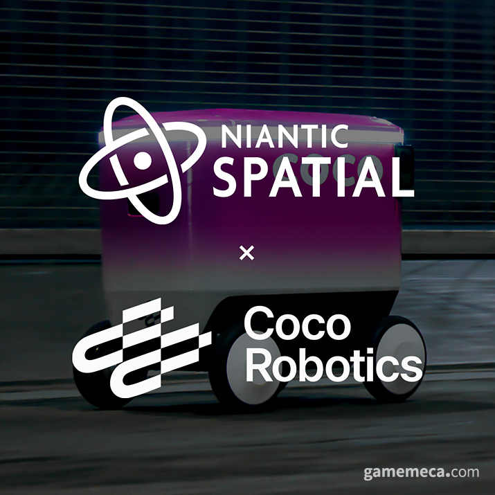
This accumulated data is being expanded into actual industrial sectors through Niantic Spatial, an AI company under Niantic. A prime example is the collaboration with the delivery robot firm Coco Robotics. Niantic Spatial stated on its official blog, "Cities are essentially obstacle courses that never stop changing. GPS signals falter amidst skyscrapers, environmental conditions shift constantly, and street closures or new pick-up points render maps obsolete in seconds." They added, "Humans can navigate this chaos with ease, but robots simply cannot."
In essence, Niantic is using the data collected through Niantic Spatial to supplement the limitations of GPS in urban environments where location accuracy is constantly fluctuating, helping robots reach their destinations more precisely. This suggests that data collected by users while playing games could be utilized for various location-based technologies beyond logistics and robotics.
However, as this news spreads, concerns regarding this method of utilization are emerging. Critics point out that while data collection is disclosed in the Terms of Service, it was not sufficiently communicated that this data would be used for commercial AI model training or robot operations. Discussions regarding user privacy are ongoing, given that precise data capable of estimating an individual's location, line of sight, and movement paths is being accumulated. Furthermore, concerns have been raised about the potential for such data to be used for military purposes amidst the increasingly volatile global climate.
나이언틱의 대표작이라 할 수 있는 ‘포켓몬 고’의 AR 데이터를 포함한 다양한 메타데이터가 배달 로봇의 정확성을 높이기 위해 사용되고 있음이 알려졌다.
해당 소식은 미국 기술 전문 매체 ‘MIT 테크놀로지 리뷰(MIT Technology Review)’를 통해 전해졌다. 나이언틱이 자사 게임을 통해 축적한 데이터를 기반으로 인공지능 기술을 고도화하고 있으며, 이를 통해 보다 정확한 위치 정보를 구축하고 있다는 내용이다. 특히 나이언틱의 주요 장르인 AR 게임 진행 과정에서 수집된 방대한 이미지와 위치 정보가 AI 학습에 활용되고 있다는 점도 함께 소개됐다.
학습의 핵심에는 게임 이용자가 직접 촬영한 이미지와 그에 결합된 메타데이터가 있다. 플레이어가 포켓몬 고의 포켓스탑이나 체육관, 각종 랜드마크를 스캔하며 보상을 얻는 과정에서, AR 기능을 통해 수집된 GPS 좌표, 촬영 각도, 시간, 날씨, 이동 정보 등이 서버에 기록된다. 이렇게 수집된 수많은 데이터를 기반으로 한 시스템을 통해 특정 지역이나 위치의 현황을 센티미터 단위로 파악할 수 있다는 것이다.
이렇게 축적된 데이터는 나이언틱 산하 AI 기업 ‘나이언틱 스페이셜(Niantic Spatial)’를 통해 실제 산업 영역으로 확장되고 있다. 대표적으로 배송 로봇 기업 ‘코코 로보틱스’와의 협업이 그 예시다. 나이언틱 스페이셜은 공식 블로그를 통해 “도시는 끊임없이 변화하는 장애물 코스다. GPS 신호는 고층건물로 인해 정확도가 낮아지고, 환경 조건은 끝없이 변환하며 도로 차단이나 픽업 등으로 인해 지도와의 불일치가 끊임없이 발생한다”며, “인간은 문제 없이 이를 파악할 수 있지만, 로봇은 불가능하다”고 밝히며 기술에 대해 설명했다.
즉, 나이언틱이 수집한 데이터는 나이언틱 스페이셜을 통해 위치 정확도가 늘 변화할 수밖에 없는 도심에서 GPS의 한계를 보완하는 기술로 활용해, 로봇이 보다 정확하게 목적지에 도달할 수 있도록 돕는다는 것이다. 이는 이용자가 게임을 하며 수집한 데이터가 물류와 로보틱스 외에도 다양한 분야의 위치 기반 기술에 활용될 수 있음을 시사한다.
다만 해당 소식이 전해지며 이러한 활용 방식에 대한 우려의 목소리도 나오고 있다. 이용약관을 통해 데이터 수집 사실은 고지되어 있으나, 이 데이터가 상업적 AI 모델 학습이나 로봇 운영에까지 활용된다는 점은 충분히 안내되지 않았다는 지적이다. 개인의 위치와 시선 방향, 동선 등을 추정할 수 있는 정밀 데이터가 축적된다는 점에서 이용자 프라이버시와 관련된 논의도 이어지고 있으며, 최근 심화되는 국제 정세 속에서 이러한 데이터가 군사적 목적으로 활용될 가능성에 대한 우려도 제기되고 있다.
This news was translated by AI.

I am dedicated to games and writing. viina@gamemeca.com
READ MORE
-
 League of Legends TCG Riftbound Reveals T1 Championship Collection
-
 Surviving the Poison Gas, New Strategy Title 'Last Furry: Survival' Released
-
 National College Student Digital Art Contest, Grand Prize Goes to Lee Ye-bin from Hansung University
-
 Presidential Cup Amateur Esports Tournament, Gwangju Representative Selection Recruitment
RECOMMENDED NEWS
MOST POPULAR NEWS
- Mabinogi Eternity, Rebuilt with Unreal Engine 5, to Begin Testing This Autumn
- Wallpaper Engine to Remove 'Application-Type Wallpapers' Due to Malware Abuse
- "We were incompetent," Sudden Attack 2 protagonists appear in Sudden Attack
- Motel PC cafes are illegal, MCST and GRAC to strengthen crackdown on 'Gametels'
- 'Cannot surpass Larian': The reason why the original creator of Baldur's Gate declined Baldur's Gate 4
- [Today's Steam] Princess Maker: Prophecy of the Children, finally you can raise her for 8 years
- Netflix to Produce Live-Action Persona Series
- [Game Recs] Steam Summer Sale, 5 'Overwhelmingly Positive' titles with record-breaking discounts
- An Entire Fantasy RPG Packed In: Neverness to Everness Version 1.2 Promises Massive Content
- SNK Announces Remaster of ART OF FIGHTING Gaiden R, Teasing King and Yuri
MEDIA PARTNERSHIPS


GAMEMECA SNS